| |
| Home |
| Project Descrition |
| Sensors Description |
| Project Team |
| Publications |
| Products |
| Contact us |
| Links |
| Welcome to PRECIPITABLE WATER Project |
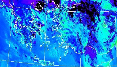
Project PRECIPITABLE WATER is a joint effort of one Greek and one Chinese Institute and one Greek Company aiming at providing accurate PW spatial distribution maps over Greece, capable of being used in regional and local studies. |
Water vapor plays a key role in the earth-atmosphere system. Through its distribution and variation, it provides an important link connecting the various components of the hydrological cycle and modulates the earth's energy budget. An important water vapor parameter currently being obtained from satellite and radiosonde measurements is precipitable water (PW).
|
| Other Projects | ||
|
||