Athens case study
Athens is a low latitude Mediterranean city that has enjoyed a positive transformation due to the Olympic Games which took place in 2004. However the city requires a substantial amount of energy for cooling and it still needs to improve air quality, to ameliorate the urban heat island and to increase free and green spaces. At the administrative level, the city needs to entrust science in its development plans so as to comply with local needs and demands.

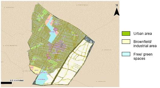
The Athens Case Study is focused on the municipality of Egaleo, which lies in the Western part of Athens. Five main road axes divide the area in four quarters. One of the quarters is an industrial degraded area (brownfield) called Eleonas. The total area of Egaleo is 650 ha and it is flat in general. The population is 74.046, although it is estimated that at least 120.000 people, mostly of medium and low income, live and work in the area. The average density is estimated to be 225 inhabitants/ha. According to onsite observations and research it was found that most of the buildings in the area were built between 1950’s and 1980’s, with several of them built around 1950’s. These buildings are made of reinforced concrete, and have one to three floors height. A small amount of houses were built in the 1920’s and onwards. These residences are made of stone and are in poor condition. Finally, there are buildings built in the last decades made of reinforced concrete reaching a height of up to 6 floors. As it appears in the land use map of Egaleo, there are very little free/ green spaces.
Egaleo is considered an environmentally degraded area facing problems with:
- Air pollution
- Traffic and transport
- Thermal discomfort
- Lack of green/free spaces
- Poor quality of building stock
- Energy
The regeneration area is Thivon Avenue. Thivon Avenue runs through 6 Municipalities of Athens, one of these being Egaleo where major improvements are proposed to address key problems in the area. The objectives of this regeneration project are to a) create thermal comfort conditions, b) improve the microclimate, c) increase green spaces and improve ventilation/ air circulation conditions, d) appropriate choice of materials e) respect the traditional architectural style of the area. The project considers three alternatives:
Planning alternative 1
Apply cool materials on all buildings at Egaleo municipality and on roads
Objectives/ impacts:
At building scale:
- Increased thermal comfort in buildings: less solar radiation is absorbed
- Increased energy efficiency: less net energy consumption on
- less expenses for the building user: reduced peak loads for cooling, cool roofs last longer
- less waste to landfills
At city scale (cool roofs and pavements):
- Increased thermal comfort outdoors
- Reduction of the heat island effect
Less air pollution and CO2 emissions (reduction on energy consumption → reduction on pollution from thermal powerplants (CO2, NOx, and PM, and O3).
Planning alternative 2
Change the land use of Eleonas (an industrial area of Egaleo) from brownfield area to built environment
- increase thermal comfort in that area
- economic advantages,
- increase of urban attractiveness
Planning alternative 3
Change the land use of Eleonas from brownfield area to green space
- increase thermal comfort and reduction of heat island effect
- decrease air pollution
- increase energy efficiency
- Carbon Storage and Sequestration
- Enhanced Stormwater Management and Water Quality
- Contribution of the increase of quality of life
- Contribution of the improvement of human health.
- Improve aesthetics and value for the whole municipality.
A. In-situ datasets of air quality, energy, water, carbon and pollutants fluxes/concentrations
The following data will be provided:
- Time series and spatially extensive data sets of air quality and surface.
- Urban heat island characteristics and energy demand of buildings for cooling.
- Indoor environmental quality.
More specifically the collected data are:
Air quality:
Concentrations of H2O, CO2, NOx, CO, O3, SO2
Particle number size distribution
Principal outdoor pollutatnts (VOCs, contaminants, etc.)
Particulate matter values - PM1, PM2.5, PM10
Indoor air quality:
Internal temperatures
Concentration of CO2
Air flow measurements
Air infiltration
Particulate matter values - PM1, PM2.5, PM10
Principal indoor pollutants (NOx, VOCs, etc.)
Thermal comfort parameters (e.g. air temperature (wet and dry bulb), humidity, air velocity, radiant temperature, black globe T)
Heat island measurements:
Air temperature data from Egaleo and air temperature data from a reference station in a suburban area
Meteorological parameters:
Air pressure
Air temperature
Precipitation
Relative humidity
Surface temperature
Micrometerological parameters:
All three wind components (u, v and w)
Wind speed and direction
Radiation:
Diffuse solar radiation
Total solar radiation
Sunshine duration
Visual comfort:
Light distribution
B. Remote sensing and GIS data and maps of energy and water fluxes, pollution concentrations, land cover and vegetation, spatial and socio-economic development
The following satellite, airborne and GIS data, in order to produce maps of energy and water fluxes, pollution concentration, land cover and vegetation, spatial and socio-economic development, are available:
- Maps of surface albedo in the visible part of the spectrum by satellite data
- Urban vegetation as derived from the multispectral vegetation index NDVI
- Land surface temperature
- Maps of surface emissivity by modelling and satellite data
- Urban land cover/land use maps
- Corine Land Cover 2000 database of Greece
- 3D maps of city (topography-3D surface characteristics)
- Digital Elevation Model (DEM)
- High resolution satellite data products
- Vector data map of the Prefectures of Greece
- Topography
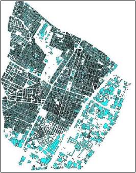
- Building blocks
- Buildings per block
- Number of buildings
- Buildings by number of floors
- Buildings by construction period
- Road network
- Transportation facilities
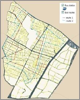
- Bus stops
- Bus routes
- Landscape
- Land use
- Urban planning zones
- Population
- Population per block
- Social features per block
- Points of interests
- Healthcare
- Churches
- Educational and Sport Units
- Squares
- Economic data per block
- Objective value zones


